Paikkatietohakemisto
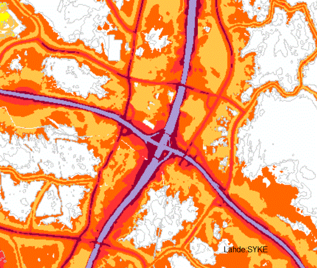
Ympäristömeludirektiivin mukaiset melualueet 2012
Vuoden 2012 EU:n ympäristömeludirektiivin mukaisen meluselvityksen melualueet.
Aineisto kuuluu SYKEn avoimiin aineistoihin (CC BY 4.0).
Käyttötarkoitus:
EU-raportointiin ja meluntorjunnan tueksi.
Lisätietoja:
https://geoportal.ymparisto.fi/meta/julkinen/Dokumentit/EUmeluselvitykset2012.pdf
The Environmental noise maps datase contains environmental noise maps from 2012. The database is based on the noise assessment report given to the EU in accordance to the Environmental Noise Directive (2002/49/EC).
This SYKE’s dataset can be used according to open data license (CC BY 4.0).
The dataset is used for reporting on environmental noise and to support noise abatement.
Simple
- Date (Publication)
- 2013-11-12
- Point of contact
-
Organisation name Individual name Electronic mail address Role Suomen ympäristökeskus
Owner
-
SYKE resource classification
-
-
Paikkatietoaineisto
-
- Keywords
-
-
Ei-Inspire
-
- Keywords
-
-
SYKEn kansallisella rajapinnalla
-
- Use constraints
- Other restrictions
- Other constraints
-
Creative Commons Nimeä 4.0 Kansainvälinen http://www.syke.fi/fi-FI/Avoin_tieto/Kayttolupa_ja_vastuut
Lähde: SYKE
- Access constraints
- Other restrictions
- Other constraints
- no limitations
- Spatial representation type
- Vector
- Denominator
- 20000
- Language
- Finnish
- Topic category
-
- Transportation
))
- Unique resource identifier
- EPSG:3067
- Codespace
-
EPSG
- Distribution format
-
Name Version ESRI shapefile
-
OGC WMS
1.3.0
OGC WFS
2.0.0
- OnLine resource
-
Protocol Linkage Name https://wwwd3.ymparisto.fi/d3/gis_data/spesific/EUMeluselvitykset2012.zip SYKEn Avoin tieto -palvelu.
https://paikkatiedot.ymparisto.fi/geoserver/syke_euymparistomeludirektiivi2012/wms Ympäristömeludirektiivin mukaiset melualueet 2012 WMS-katselupalvelu
https://paikkatiedot.ymparisto.fi/geoserver/syke_euymparistomeludirektiivi2012/wfs Ympäristömeludirektiivin mukaiset melualueet 2012 WFS-latauspalvelu
- Hierarchy level
- Dataset
- Statement
-
Paikkatietokanta on suunniteltu ja tehty SYKEssä. Aineisto perustuu eri meluselvityksien meluvyöhykkeitä kuvaaviin shape-tiedostoihin. Shape-tiedostojen paikkatietoja on jalostettu SYKEssä ennen niiden paikkatietokantaan lukemista. Jalostaminen on käsittänyt mm. koordinaatistomuunnoksia, topologian muodostamista, laskenta-alueiden välisten epäjatkuvuuksien poistamista sekä uusien ominaisuustietojen laskemista.
The spatial dataset has been developed in the Finnish Environment Institute. The dataset includes environmental noise zones as shape files. The environmental noise zones are originally outlined based on various noise assessments and quality of the data has been improved before merging it with the database. The improvements have included coordinate system changes, creating topology, ensuring the consistency and uninterrupted structure of the noise calculation areas, removing areas smaller than 100m² and calculation of new feature data.
- File identifier
- {FCF0230E-07C1-48FF-A762-B51F1332F1DC} XML
- Metadata language
- Finnish
- Character set
- UTF8
- Hierarchy level
- Dataset
- Date stamp
- 2023-05-26
- Metadata standard name
-
ISO 19115
- Metadata standard version
-
2003/Cor.1:2006
- Metadata author
-
Organisation name Individual name Electronic mail address Role Suomen ympäristökeskus
Owner